UNESCO added 20 new sites of biosphere reserves and extended several others last week. Biosphere Reserves were inscribed in Haiti, Kazakhstan, and Sao Tome and Principe for the first time this year. The Biosphere Reserves initiative defines areas designated under UNESCO's Man and the Biosphere (MAB) Program that serve as places to test different approaches to integrated management of terrestrial, freshwater, coastal and marine resources and biodiversity. Biosphere Reserves are thus sites for experimenting with and learning about sustainable development. See our Blog for Film: “Underwater Heritage-UN”.
Below is a brief description of the Biosphere Reserves designated, the MAB Program as well as Links. Check out Photo Gallery section at the MAB site for many more great pictures as those incorporated here.
Ambassador Muhamed Sacirbey - FOLLOW mo @MuhamedSacirbey
Facebook-Become a Fan at “Diplomatically Incorrect”
Twitter – Follow us @DiplomaticallyX
See more at our Popular Video Blogs & Current News Event Articles – Ecology-Diplomat Channel
The Man and the Biosphere (MAB) Programme is an Intergovernmental Scientific Programme aiming to set a scientific basis for the improvement of the relationships between people and their environment globally. Launched in the early 1970s, it proposes an interdisciplinary research agenda and capacity building that target the ecological, social and economic dimensions of biodiversity loss and the reduction of this loss. Concerned with problems at the interface of scientific, environmental, societal and development issues, MAB combines natural and social sciences, economics and education to improve human livelihoods and safeguard natural ecosystems, thus promoting innovative approaches to economic development that is socially and culturally appropriate and environmentally sustainable.
The agenda of the MAB Prorgamme is defined by its main governing body, the International Co-ordinating Council in concertation with the broader MAB Community.
Sub-programmes and activities focus on specific ecosystems: mountains; drylands; tropical forests; urban systems; wetlands; and marine, island and coastal ecosystems. Interdisciplinary and cross-sectoral collaboration, research and capacity–building are promoted.
For implementation of its interdisciplinary work on-ground, MAB relies on the World Network of Biosphere Reserves, and on thematic networks and partnerships for knowledge-sharing, research and monitoring, education and training, and participatory decision-making.
New MAB Designated Biosphere Reserves:
Salzburger Lungau & Kärntner Nockberge, Austria, is a representative example of inner-alpine landscapes with high mountains and deep valleys. It is a richly structured landscape ranging from 600 m to 3,000 m above sea level and encompasses typical ecosystems of the Central Alps such as mountain meadows and mires with great biodiversity. The site covers an area spread over two provinces. The Kärntner Nockberge part is a whole national park covering 149,000 ha. Apart from hunting and gathering, early farming techniques including meadows for fodder, trade and mining have been important ways for earning a living in the region. The permanent population is 33,350, of which 21,000 live in small towns. More than 50% of the jobs are found in construction industry, public health sector and commercial goods industries (cosmetics, luxury food, wood, rubber, plastics). In the side valleys, service sectors including tourism are the most important job providers.
West Polesie Transboundary Biosphere Reserve, Belarus/Poland/Ukraine
This transboundary is located in the Central European Biogeographical Region, and is characterized by boreal coniferous forests and temperate zone deciduous forest at the junction. The region contains a number of lakes, mires, meadows, swamp and lake complexes with peculiar flora and fauna, including a number of rare and endangered species. The area represents and protects unique landscapes and traditions on the cultural edge of both Eastern and Western Europe. The main economic activities of this area are agriculture, tourism, weekend recreation, and sustainable forestry and fishing. Many stakeholders (universities, local communities, NGOs, local authorities, etc.) have been involved in the design of the transboundary biosphere reserve.
Jinggangshan, China, has a mid-subtropical humid monsoon climate and diverse landscapes of mountains, valleys, structural basins and Karst with elevation varying from 381 m to 1,779 m above sea level. It is the largest continuous area of primary broad leaf forest ecosystem in the whole sub-tropical zone. There are 3415 higher plant species (with mutant species). Local residents live on agriculture and forest industries, such as rice, potato, vegetables, bamboo and tea-tree oil cultivation. The tourism industry at Jinggangshan has developed not only because of the marvellous landscapes and scenic spots but also because of its historical sites linked to China’s revolution.
Niubeiliang, China, is located at the eastern segment of the Qinling Mountains, with a typical temperate broad-leaved mixed mountain forest system. More than 94% are covered by forests, shared by three administrative counties. It has been regarded as an important water conservation region for Xi’an, a provincial level city and southern Shaanxi province. Niubeiliang enjoys a high level of biodiversity with many endangered species including Golden Takin (Budorcas taxicolor bedfordi) and Dwarf Musk Deer (Moschus berezovskii). Local residents in transition area have developed rural tourism for increasing their incomes. Activities in the transition area of Niubeiliang include agriculture, animal husbandry, forest products. Cooperation with colleges and research institutions, research, monitoring, public awareness and training programs have been actively developed.
Mura-Drava-Danube, Croatia/Hungary
The biosphere reserve includes Central Europe’s largest floodplain system, as well as areas that were part of the floodplain before river regulation. The areas along the course of both the Danube and the Drava form a continuous stretch of habitats extending across the state border. The Mura-Drava River also has a variety of typical plant and animal communities. It contains a variety of wet habitats, including those that are among the most threatened in Europe (alluvial forests, wet grasslands, gravel and sand bars, oxbow lakes, abandoned riverbed…).
One of the major functions of the biosphere reserve is to provide a possibility for the revival and modernization of floodplain management, which would ensure an extra source of living for local people, and help preserve the natural values of the floodplain region. Major activities in the area are agriculture, forest management, sand and gravel extraction, industry (diverse types), and ecotourism.
Sheka, Ethiopia, covers a total area of 238,750 ha and consists of forests, bamboo thickets, wetlands, agriculture lands, rural settlements and towns. The forest in Sheka which is also part of the Southwest Highlands Forests of Ethiopia is important for the conservation of the Afromontane forest vegetation types, especially the Afromontane Rainforest and Alpine Bamboo thickets. The area is rich in plant and animal life with over 38 threatened species of flora and fauna. The local population is deeply committed to maintaining the integrity of the ecosystem through the practice of ecologically sustainable agriculture.
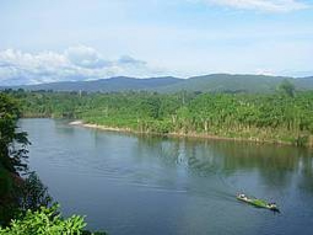
Bassin de la Dordogne, France, consists of the whole Dordogne watershed, which is a hydro system of 24,000 km². The Dordogne’s catchment area shelters great biodiversity and represents a range of mountainous landscapes. It contains one of the biggest estuaries in Europe. Population density is low and there are no large cities. Main activities include tourism based on natural and cultural heritage, agriculture and forest exploitation. The area is one of the three most important hydroelectric power production centres in France. This creates considerable pressure on the water and aquatic ecosystems.
La Selle, Haiti, is the country’s first biosphere reserve. The area includes a large number of different ecosystems (mountain, plain, tropical dry forest and coastal ecosystems) and protected areas like La Visite or Forêt-des-pins (with the endemic species, Pinus occidentalis). It is located in the ecological continuum of the Jaragua-Bahoruco-Enriquillo Biosphere Reserve of the Dominican Republic and contributes to the Caribbean Biological Corridor as an example of collaboration among countries. Four percent of the Haitian population lives in the biosphere reserve and the main economic activities are agroforestry, fishery, tourism, and handicraft industry.
Achanakmar-Amarkantak, India located at the junction of hill ranges, with topography ranging from high mountains, shallow valleys and plains. Moist deciduous forests constitute 63% of the area. There is a rich biodiversity of great conservation value at this site. Different types and methods of forest management are practiced inside this site. The core area of Achanakmar-Amarkantak consists of the protected forest land while the buffer zone and the transition area are characterised by forests, agricultural and rehabilitated land and small suburban clusters. Twenty-seven tribal and non-tribal communities inhabit 418 villages living on agriculture (including production of medicinal plants) and non-timber products produced in the buffer zone and transition areas. Ecological studies on the restoration of degraded forest land, the conservation of medicinal plants and their sustainable harvesting are being conducted at Achanakmar-Amarkantak. The research findings are documented and applied to continue improving management of the site.
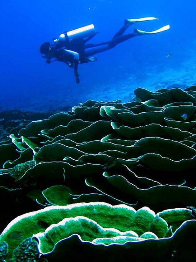
Wakatobi, Indonesia, includes the four main islands of Wangi-Wangi, Kaledupa, Tomia, and Binongko. It has diverse ecosystems with many marine and coastal species of seagrass, coral reefs, fish used both for consumption and for sale, sea birds, turtles, cetaceans, and mangroves. There are about 590 fish species and 396 reef at Wakatobi Islands. The core area of this site is of great value in the protection of marine ecosystems and the habitats of various important plant and animal species. Wakatobi seeks to become a learning laboratory for researchers, students, local government, NGOs, the public and private sectors, and other stakeholders.
Aya, Japan, in the eastern part of Japan’s southern Kyushu Island, harbors one of the country’s largest remaining lucidophyllous forests. The total area of 14,580 ha. includes Aya Town in the transition zone, which has a population of 7,283. The core area is made up of the preserved district of the Aya Forestry Ecosystem Protected Area and is included in the Kyushu Central Mountains Quasi National Park. The area has never been used for human activities and is the object of scientific studies on the structure, function and dynamics of the lucidophyllous forest. The transition zone is mainly used for organic agriculture, and Aya Town is the first community in the country to develop a traditional recycling-oriented agricultural system, put in place in 1988. Ecotourism, including “forest therapy” (for healing purposes) and forest environmental education, is actively developed.
Korgalzhyn, Kazakhstan, is Kazakhstan’s first biosphere reserve. Situated in the northern/central part of Kazakhstan, the site is a complex of freshwater and saline lakes embedded in the dry steppe zone of Eurasia. This makes it an important wetland site for migratory water birds (including globally threatened species, among them the extremely rare Siberian white crane, the Dalmatian pelican and Pallas’ fish eagle). Korgalzhyn State Nature Reserve is also one of the clusters of the UNESCO World Heritage site “Saryarka – Steppes and Lakes of Northern Kazakhstan”. The total proposed area covers 1,603,171 ha. About 12,500 people live in the area. The territory is characterized by elevated plains, hills, lake depressions and marked by an extreme-continental climate. Human emigration caused by overall environmental degradation (unsustainable use of water and biological resources, unsustainable tourism) is now being addressed through a variety of pilot projects such as sustainable pasture management, ecotourism, the creation of fishing and hunting farms, and the development of alternative power sources.
Tehuacán-Cuicatlán, Mexico, is located on an arid mountain and high lands system and has one of Mexico’s highest rates of biodiversity and endemic species. It is the most emblematic of the old landscapes of Mesoamerica and is host to eight different ethnic groups. It includes the original domestication sites for maize, pumpkin, avocado and beans. The most relevant ecosystem is a densely wooded expanse of arborescent cactus species (bosque de cactáceas columnares) and the tropical dry forest (selva baja caducifolia).
The Island of Príncipe, Sao Tome and Principe, is the country’s first Biosphere Reserve. It is the oldest of three oceanic volcanic islands in the Gulf of Guinea. The area includes the entire emerged area of the island of Príncipe, its islets and Tinhosas islands. It is home to great biodiversity in terrestrial as well as in marine ecosystems, and is an important place for the reproduction of sea turtles, seabirds and cetaceans. The main economic activities are agriculture, fishing and tourism. It can be considered as a model for promoting integrated eco-tourism development in similar islands and may serve as the basis for a larger marine and terrestrial buffer zone.
Ferlo, Senegal, occupies a total area of 1,150,000 ha. Despite threats to the ecosystem caused by drought and human activities, it is home to a remarkable variety of flora and fauna. In particular, the Ferlo is home to emblematic species like the redneck ostrich, the red fronted gazelle and the endangered African blackwood (Dalbergia melanoxylon). Traditional activities include pastoralism and agriculture. Ecotourism, aquaculture or sustainable forestry will be promoted in order to diversify sources of income of the population. Ferlo also hosts several research institutions.
La Gomera, Spain, is part of the Canary archipelago, situated in a central location surrounded by the Tenerife, La Palma and El Hierro islands. The Garajonay National Park is located in the central part of the island. It maximum height is 1,487 m (Alto de Garajonay). However the central plateau (1,000 meters of altitude) and the formation of radial and deep ravines is the result of intense erosion. It provides an exceptional landscape. The humidity and the cloud from the sea is often stopped on this plateau and produces a “sea of clouds” effect. The park is also a UNESCO World Heritage site and is noted for its laurisilva rainforest ecosystem. The landscape is also modelled by agricultural terraces that have strong cultural significance.
Las Ubiñas-La Mesa, Spain, is located in the central zone of the Cantabrian Range. It encompasses an old growth forest, which maintains pristine conditions and high biodiversity. The area also has protected species such as the Cantabrian brown bears, woodpeckers as well as unique domestic species. It has a rich cultural heritage. Las Ubiñas –La Mesa Park also includes several human settlement sites dating back to the Neolithic period. It is surrounded by other biosphere reserves such as : Babia, Los Valles de Omaña y Luna, Alto Bernesga and Somiedo.
East Vättern Scarp landscape, Sweden, is Sweden’s second largest cold water lake, and the fifth largest lake in Europe, with a total surface of 105,520 ha. Almost 40,000 people live in the area. The majority of the biosphere reserve is dominated by agriculture and forestry lands, with villages and settlements consisting of small farms and individual homes. There are also several large scale farms and manors, as well as three urban areas. The core areas consist of existing nature reserves, protected forest habitat and shorelines. Adaptation to climate change and its mitigation is one key objective of this biosphere reserve, with many research and activities underway.
Bashkirskiyi Ural, Russian Federation, is located in the western slopes on southern Ural and covers a total surface area of 345,700 ha. It has a a site of rich diversity, with a variety of landscapes from mountain river gorges, to mountains steppes, meadows, floodplains and reservoirs. There are more than 1,650 plant species, of which 44 are endemic, and over 2,000 animal species. The site contains five different protected areas, including national parks and forestry districts. There are unique archaeological sites linked to culture and history of the Bashkir people as well as the cult cave of “Shulgan Tash” preserved since the Stone Age. The total resident population is 14,957 with main activities being forestry and small scale farming, traditional bee keeping and, increasingly, tourism (180, 000 visitors from May to September).
Galloway and southern Ayrshire Biosphere, United Kingdom, represents the merging of two biosphere reserves covering a total area of 520,000 ha. It is composed of open field landscapes, lochs, moorlands, arable lands, pastures and afforested areas. The site has a very low human density with less than 100,000 inhabitants, and has suffered economically and socially from the closing of local mining and textile industries. There are few cities with no more than 10,000 inhabitants. The biodiversity is very high with important populations of grouse, golden eagles and mountains hares. The core area is composed of various protected areas under the management and ownership of the Scottish National Heritage. Tourism is growing, with more than 850,000 visitors per year.
Extensions of Biosphere reserves:
Fray Jorge Biosphere Reserve, Chile. This extension incorporates the transition area that was not included during the nomination in 1977 and enlarges the buffer zone. The Biosphere Reserve has thus more than doubled in size. The area represents the “dwarf coastal cloud shrub-land habitat”, harbouring succulents and thorny shrubs comprised in the arid and semi-arid Mediterranean type plant formation of Mediterranean Chile. Biomes such as river, estuary (the mouth of the Limary River), coastline, semi-arid sclerophyll shrub land and evergreen relict forest are represented. The new extension surrounds the Bosque Fray Jorge National Park with a new zoning system to implement the Statutory Framework.
Réserve de biosphère des Iles et de la Mer d’Iroise Extension and renaming (former Iroise), France. The extension of Mer d’Iroise, which now includes a marine park and the island of Sein is based on engagement and support from local communities with a clear vision for sustainable development supported by a charter. The total surface area is 99,149 ha, with 1,324 inhabitants.
Doñana Biosphere Reserve, Spain, Extension. This biosphere reserve was designated in 1980. The new extension incorporates the transition area that was not included in the previous nomination and enlarges the buffer zone, tripling the total area of the Reserve. This is one of the most important wetlands areas and covers diverse landscape units. The coastal strip includes beaches and chain dunes, alternating with forests, centenary pine trees, and complex lagoon systems interconnected by the water-table. The core area and buffer zone have only light infrastructure dedicated to research, public use, institutional events and surveillance activities. The transition area has 190,000 inhabitants in la Comarca municipality. Seasonal tourism increases the population to 500,000 in the summer months.
Sierra Nevada Biosphere Reserve, Spain, Re-zoning. This biosphere reserve was nominated in 1986. This new submission is a re-zoning that incorporates the transition area that was not included in the previous nomination. It now includes the inner mountain nucleus of the Cordillera Penibética mountain range which has the Spanish Peninsula’s highest peaks including the Mulhacen peak (3,482 m.) The steep mountain slopes are a reflection of its past, modelled by glacial erosion. What confers an extraordinary value on the Sierra Nevada, in addition to its grandiose landscapes, are the numerous unique and endemic species of flora found in this area.
Related links:
- More information on the biosphere reserves
- More information on the MAB-ICC
- Photo Galleries
- Videos on the new biosphere reserves


