HARIPUR , PAKISTAN
The Haripur is District and Tehsil in HazaraDivision, KhyberPakhtoonKhawa Pakistan. Haripur is Historical place which is on the name of Sikh whose name was “Hari Singh Nalwa”. The city Haripur is on the altitude of around 610 meters (2,000 ft) above sea level.
Haripur is the main city of the Haripur District in the Hazara Division, Pakistan and it is 65 km (40 mile) north to Islamabad and 35 km (22 miles) south of Abbottbad. The city lies on the Karakoram Highway.
Haripur was remaining the headquarters of Hazara until from 1822 to1853. A small river, the river Dore, passes through the city, feeding the Tarbela Dam.The Haripur district is situated at the heart of the ancient Gandhara Civilization.
LANGUAGE:
Hindko (A Punjabi Variant) is main language which is spoken in Haripur. Urdu being National language is also spoken and understood; moreover maximum people understand and speak English and Pashto as well.
RULE OF TURKISH IN HARIPUR:
In 1399, the Muslim warrior Taimur positioned his Turk soldiers in Hazara to protect the important route between Kabul and Kashmir. During the period of Mughal rule, local Turkish chiefs acknowledged Mughal authority. In fact, Pakhli provided the main in the 18th century; Turkish rule came to an end (1703).
DURRANI RULE IN HARIPUR:
After the Turkish rule Shah Durrani expanded his kingdom to Punjab, Hazara also came under his control. Durrani considered it intelligent to rule the area through local tribal chiefs, especially the Tareens. The Durrani’s rule ended abruptly in the beginning of the 18th century.
SIKH ANNEXATION
The Sikhs take control of Hazara in two phase: first, Lower Hazara and second Upper Hazara. The town of Haripur (meaning 'Hari's town') was founded in 1822 by Hari Singh Nalwa, the Commander-in-Chief of Ranjit Singh's army. Haripur was donated to Nalwa in 1821 as a Jagir On the successful completion of his tenure as Governor of Kashmir. As soon as Nalwa received this grant, he built the walled town of Haripur in the heart of the Haripur plain.
BRITISH INDIA’S RULE:
Haripur was the sole example of a planned town in this region until the British built Abbottabad many years later. Haripur Hazara was the capital of Hazara until 1853. It continued to grow, finally becoming a city and later a district.
The District of Haripur was a Tehsil or sub-division of Abbottabad District until 1992 when it became a district in its own right. The district is 2010–2011 represented in the Provincial Assembly by four elected MPAs. One of those four MPA's is elected to the National / Federal Assembly. Currently, Haripur District is divided into two Tehsil’s, further subdivided into 44 Union Concils which are as;
Haripur Central, Haripur North, Haripur South, Khalabat Township, Sarai Saleh Hattar,Ali Khan, Bagra, Baitgali, Bakka, Bandi Sher Khan, Barkot, Beer, Behki,, Bherrary, Breela, Darwesh, Dheendah, Dingi, Ghazi, Jabri, Jatti Pind, Kalinjar, Khanpur, Kholian Bala, Kot Najeebullah, Kotehrra, Kundi, Landarmang, Mankrai, Maqsood, Najifpur, Nara Amaz, Pandak, Panian, Pind Hashim Khan, Pind Kamal Khan, Qazipur, Rehana, , Serai Niamat Khan, Sikandarpur, Sirikot, Sirya, Tarbela, Tofkian
NATURAL RESOURCES:
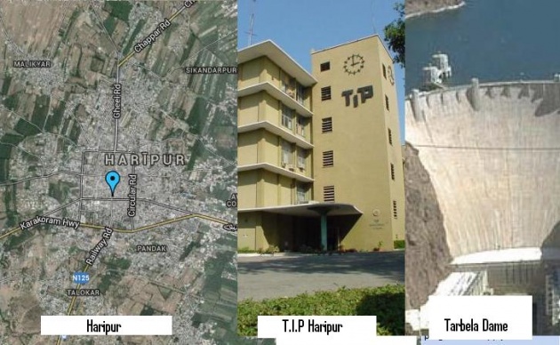
The area is rich in natural resources and contains two important reservoirs, which are Tarbela Dam and Khanpur Dam.
Haripur is a green valley, rich in fruits and vegetables, and serves as the base market for the mountainous cities of Abbottabad and Mansehraand also the rest of Hazara Division. Haripur is famous for its Guavas. Khanpur is one of the main areas of Haripurdue to theKhanpurLackand RedBloodOranges are very famous in the Pakistan and also supplied in the international market and.
GEOGRAPHICAL FEATURES OF HARIPUR
Geographically, Haripur is the gateway to HazaraDivision because Haripur built the link between the HazaraDivision and the Pakistani capital Islamabad.
Telephone Industries of Pakistan (TIP), the biggest telephone factory in Asia and National Radio Telecommunication Corporation (NRTC) are in Haripur. The industrial area of Hattar is closer to Haripur.
Several miles to the south of Haripur lays the ancient Buddhist university town of Taxila. To the north is the world's largest rock-filled dam, the TarbelaDam. Also to the south lies the picturesque KhanpurDam, that supplies drinking water to Islambad and Rawalpindi.
Haripur has a Universityof Haripur and campus of AllamaIqablOpenUniversity and also the campus of HazaraUniversity, DhodialMansehra.
CLIMATE
Climate of Haripur characterized by relatively high temperatures and consistently distributed rainfall throughout the year. This climate type is found on the eastern sides of the continents between 20° and 35° N and S latitude.
The people of haripur like the Shalwaar Kameez. Thay are very hardworker, sincere, having fair skin color. They are very Hospital (Mehman Nawaaz). They welcome the gusts whole heartedly.