INTRODUCTION OF THE AREA AND LINE
Hydrocarbons play a vital role in the growth of economy of any country and have wide uses at smaller scales in everyday life as well. Geoscientists are trying since a long time for the exploration of hydrocarbons from subsurface and are applying different methods in this regard.
Geophysical methods are the most widely used methods in the exploration of hydrocarbons; especially Seismic Method has a great importance in this regard.
Pakistan has a high potential of hydrocarbons and consists of three major sedimentary basins (covering more than 2/3rd of its area) namely, Indus Basin in the east, Baluchistan Basin in the west and Pishin basin in the northwest. Indus and Baluchistan basin are separated by Ornach Bela transform fault zone and the Pishin basin lies between Indus and Chamman transform fault.
A variety of sub-basins, fold belts and monoclines with variable structural styles resulting from diverse geodynamic conditions have been identified in Baluchistan Basin and Indus Basin (Kadri, 1995). Indus is the only producing basin of Pakistan where 83 oil and gas fields have been discovered. The Indus Basin covers an area of about 533,500Km2 and contains more than 15,000m thick sediments ranging in age from the Precambrain to recent. This giant basin has been divided into three compartments based on structural highs namely, The Jacobabad Khairpur High, Mari Khandkot High (Sukkur Rift) and the Sargodha High (Kazmi & Jan, 1997). Indus basin is divided into Upper Indus Basin, Middle Indus or Central Indus Basin and Lower Indus or Southern Indus Basin.
In the present work, an attempt has been made to observe geological structures present in the subsurface in the area of study to mark the structural and stratigraphic traps. Reservoir characterization is being done to confirm whether economic quantity of hydrocarbons may accumulate in the reservoir rock or not.
Location
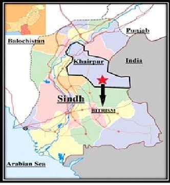
The study area lies in lower Indus basin and the geographic coordinates of the area are:
Latitude: 26° 25'N
Longitude: 69°0'E
Geographic location of the study area is shown in figure
Objective
The purpose of this dissertation is to understand the stratigraphic and structural frame
seismic and well data.
2-Dimensional Structural interpretation of Seismic line 20027-BTM-02 using
interactive tool of Kingdom software.
Study the geology of the area and understanding the structure types.
Understanding the paleo-structure dynamics by interpreting the geological units.
Solving seismic velocities using Matlab programming to prepare the average velocity grap
-h to show temporal traits of velocity.
Preparation of Iso-velocity graph to observe the lateral and vertical velocity variations
inthe area of study.
Preparation of Time and Depth sections and study their differences.
Rock physics properties and Petrophysical analysis of the reservoir rocks using
well data and preparation of synthetic seismogram.
Theises work of Zahid Latif
By @samali