LEVELLING:
A level surface is any surface parallel to the mean spheroidal surface of the earth.
A level line is a line lying in a level surface.
A horizontal plane through a point is a plane tangential to the level surface at that point. It is perpendicular to the direction fo gravity (plumb line).
A vertical plane is a plane containing a vertical line.
The elevation of a point is its vertical distance above known as the reduced level (R.L). The elevation of a point is plus or minus according as the point as above or below the datum.
The difference in elevation (H) between two points is the vertical distance between the level surfaces passing through the two points.
A bench mark (B.M) is a fixed reference point or known elevation.
The line of collimation is the line joining the intersection of the crosshairs to the optical centre of the object glass and its continuation. It is also called the line of sight.
An axis of the telescope is a line joining the optical centre of the object glass to the centre of the eye-piece.
A backsight (B.S), also termed as a backsight reading, is a staff (or rod) reading taken on a point of known elevation, as on a bench mark or a change point. I
A foresight (F.S) also called a foresight reading, is a staff (or rod) reading on a point whose elevation is to be determined as on a change point. It is also termed
An intermediate sight (I.S) is any other staff reading taken on a point of unknown elevation from the same set-up
A change point (C.P) is a point denoting the shifting of the level. It is a point on which the fore and backsight are taken. Any stable and well-defined object such as a boundary stone, curb stone, rail, rock, etc. is used as a change point. A bench mark may also be taken as a change point. It is also called a turning point (T.P).
A station is a point whose elevation is to be determined or a point which is to be established at a given elevation. It may be noted that it is a point where the staff is held and not the point where the level is set up.
The height of instrument (H.I) is the elevation (or the R.L) of the plane of collimation (or plane of sight) when the instrument is correctly leveled. It is also called the “height of plane of collimation” or the collimation.
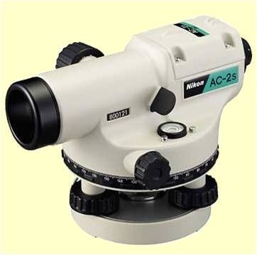
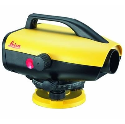
Equipment for Leveling: - The equipment for leveling consists of
(i) Engineering Level,
(ii) Leveling staff,
(iii) chain or tape for measuring horizontal distances
(iv) Level field book for recording the staff readings, distances, and other field notes.
LEVEL:
The instrument which is used for leveling, is known as level. It consist essentially of the following parts.
A levelling head to bring the bubble of the tube level at the centre of its run.
A tripod to support the above three parts of the level.
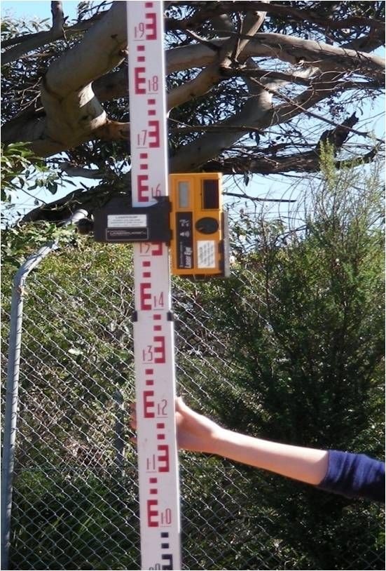
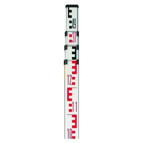
THE LEVELLING STAFF
The leveling Staff is used to determine the vertical distance’s of the points below the horizontal line of sight.
There are various types of graduated Staff :
Folding type 4-meter leveling Staff
Invar precision leveling Staff
Target Staff
Bar Coded Staff
For work of ordinary accuracy we use folding staves of 5 meter length or 16 ft length. For high degree of accuracy 3 meter long invar staves are used which do not fold.
HOLDING THE STAFF
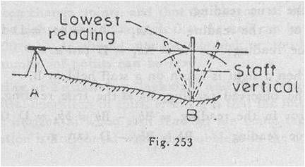
Utmost care should be taken in holding the staff truly vertical while the reading is taken. To hold the staff in a vert, with the heel of the staff between his toes, and holds it between the palm of his ical position, the staff man stands hands at the height of his face. If it is not vertical, the reading will be too great. Special care must be exercised with larger readings, since the error due to a given deviation from the vertical vary with the readings. In precise leveling, the staff is equipped with a folding circular level or a pendulum plumb bob to make it plumb while in ordinary leveling, the staff is waved slowly forward, i.e. towards the level, and backward, i.e. away from the level, and the lowest reading taken to avoid these errors.
BENCH MARKS
Bench Marks:
There are four kinds of bench marks:
(i) G. T. S. (Great Trigonometrical Survey)
(ii) Permanent
(iii) Arbitrary
(iv) Temporary
G.T.S Bench Marks:
These bench marks are established by the Survey of Pakistan with greatest precision at an interval of 100 Km (normally) all over all country. Their elevation refer to the mean sea level datum obtained by hourly observations of the tides over a specific time frame. These are depicted on the topo sheets published by the Survey of Pakistan and their elevations correct to two decimal points of a decimal of a meter, are entered.
Permanent Bench Marks:
These bench marks are established between G.T.S bench marks by the Survey of Pakistan , or other government agencies such as PWD, on clearly defined and permanent natural or cultural detail points such as isolated rocks culverts, kilometer stones, railway platforms, gate pillars of inspections houses, etc.
Arbitrary Bench Marks:
These are the reference points whose elevations are arbitrarily assumed for small leveling operations. Their elevations do not refer to any fixed datum as in case of G.T.S. or permanent bench marks. Temporary Bench Marks:
These are the reference points on which a day’s work is closed and from where leveling is continued next day in the absence of a permanent bench mark. Their elevations are referred to as the reduced levels. Such bench marks are carefully established on permanent detail points such as kilometer stones, parapets, floor of verandahs, root of old trees, etc. Their correct descriptions should invariably be written in level books.
Steps in Leveling: -
There are two essential steps in leveling. There first step is to find the elevation or R.L. of the plane of collimation (H.I) of the level by taking a backer sight on a bench mark.
The second step is to find the elevation or R.L. of any other point by taking a reading on the staff held at that point.
PRINCIPLES OF LEVELLING
Simple leveling:
It is the simplest operation in leveling when it is required to find the difference in the elevation between two points, . Suppose A and B are two such points and the level is set up at O, approximately midway between A and B. The staff reading is then taken. Let the respective readings on A and B be 2.340m and 3.135m. The difference between these readings gives the difference of the level
If the R.L of A is 100, the R.L of B may be found as:
Differential Leveling: - This method is used in order to find the difference in elevation between two point. (i) If they are too far apart, or (ii) If the difference in elevation between them is too great, or In such a case, it is necessary to set up the level in several positions and to work in a series of stages. The process is also known as compound or continuous leveling.
Reduction of Levels: -
The collimation or instrument height system
The rise and fall system
The collimation system:
It consists in finding the elevation of the plane of collimation (H.I. for every set-up of the instrument, and then obtaining the reduced levels of points with reference to the respective plane of collimation.
Arithmetical Check:- The difference between the sum of the backsights and the sum of the foresights should be equal to the difference between the first and the last reduced levels. This check verifies the calculation of the reduced levels of the planes of collimation and of the change points only. There is no check on the reduction of the intermediate reduced levels.
The Rise and Fall System:
It consists in determining the difference of level between the consecutive points by comparing each point after the first with that immediately preceding it.
The difference between their staff readings indicates a rise or fall according as the staff reading at the point is smaller or greater than that at the preceding point. The reduced level of each point is then found by adding the rise to, or subtracting the fall from the reduced level of the preceding point.
Arithmetical check:- There are three checks on the accuracy of the reductions. The difference between the sum of the back sights and the sum of the foresights = the difference between the sum of the rises and that of falls = the difference between the first and the last reduced levels.
ΣB.S – ΣF.S = ΣRISE – ΣFALL = LAST R.L – FIRST R.L
GADIENT.
Gradient = Horizontal Distance / Difference in level