Photogrammetric Surveying:
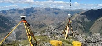
In this type of survey, maps of certain areas are prepared from the photographs taken from the ground and / or aircrafts. The said maps are used to interpret the activities related to Geology, Topography, Land Measurement, Soils, Buildings, Archaeological Remains, Crops, Water-bodies, Forests and Crime-Scenes. When the photographs are taken from a fixed position from a camera held or mounted on or near the ground, such type of Photogrammetry is called Terrestrial Photogrammetry. And when the photographs are taken from the camera held or mounted on the aircraft flying over the area, such type of Photogrammetry is called Aerial Photogrammetry. The best mapping result for a large project is obtained from the Aerial Photogrammetry. The said techniques mainly involve the production of 2D images for the 3D objects. As these techniques also involve measuring the objects by taking the photographs without touching the said objects. So, a number of authors use the term “Remote Sensing” for Photogrammetry too. But currently all the authors are using the term Remote Sensing for taking the photographs from the satellites instead of aircrafts. Photogrammetry is principally used for Interpretation and Measurement of the objects using Photography. Photographs are taken from two point of views: (i) Measurement: Such type of Photogrammetry is known as “Metric Photogrammetry” and (ii) Interpretation: Such type of Photogrammetry is known as “Interpretive Photogrammetry”. Photogrammetry is useful in hilly areas (to have good contouring of the terrain), without forestation. Other important information are: Requirement of accuracy and clarity of photographic results at some sites and of some objects; Oblique Photographs in Aerial Photogrammetry; Angle of Photography; A number of particular definitions; Scale; Height of taking photographs; Ground Coordinates; Flying Height, Speed and Timing; Synchronization; Number of Photographs to be taken and Photographic Overlaps to be done
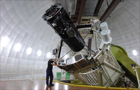
ASTRONOMICAL SURVEYING: It is a scientific activity of producing a general map or image of a region of the sky which lacks a specific observational target. Alternatively, an astronomical survey comprises a set of many images or spectra of objects which share a common type or feature. Astronomical Surveys are often restricted to one band of the electromagnetic spectrum due to instrumental limitations; although multi-wavelength surveys are also made by using the multiple detectors, each sensitive to a different band-width (Band-width: Numerical difference between the upper and lower frequencies of a band of electromagnetic radiation, especially assigned range of the radio frequencies). Astronomical Surveying is also known as Sky surveying. It is, unlike targeted observation of a specific object, allow astronomers to catalogue the celestial objects and perform the statistical analyses on them without making lengthy observations. In some cases, an astronomer interested in a particular object will find that survey images are sufficient to entirely avoid the need for telescope-using activity and time.Methods and Equipment used in Astronomical Surveying: Optical, Infra-red, Radio-waves, and Gamma Rays
Definitions of Astronomy and Celestial Sphere are required / used in this survey.GIS (Global Information System) Surveying: It is a computer-system based Surveying method. This type of method is used for surveying of the objects mentioned in Photogrammetric Surveying. Implementation of a GIS Surveying is often driven by the jurisdictional purpose (e.g. survey of a city or forest or construction project, etc) or application requirements. In a general, the term describes the system and displays GIS for decision making; it mainly includes the geographic concepts, applications and system. First of all, this term had been used.Application of GIS: GIS is a relatively broad term that refers to a number of different technologies, processes, and methods. It is linked with many operations and has many applications. It is related to engineering, planning, management, transport / logistics, telecommunications, insurance and business.Technology and Equipment: Modern GIS technology is using the is transferred into a digital medium through the use of a CAD software, and geographical-info referencing techniques.