Moraine Lake

Moraine Lake is a glacially-fed lake in Banff National Park, 14 kilometres (8.7 mi) outside the Village of Lake Louise, Alberta, Canada. It is situated in the Valley of the Ten Peaks, at an elevation of approximately 6,183 feet (1,885 m). The lake has a surface area of .5 square kilometres (0.19 sq mi).
The lake, being glacially fed, does not reach its crest until mid to late June. When it is full, it reflects a distinct shade of blue. The colour is due to the refraction of light off the rock flour deposited in the lake on a continual basis.
Tourism
Hiking trails
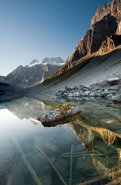
Lower Consolation Lake in Banff National Park in Alberta, Canada.
The area around the lake has several walking/hiking trails which are, from time to time, restricted. This is the one most commonly taken by tourists. The Rockpile Trail along the actual moraine is approximately 300 metres long, with an elevation change of 24 metres (79 ft). The view of the lake from the top of the rockpile is one of the most photographed locations in all of Canada. That view of the mountains behind the lake in Valley of the Ten Peaks is known as the Twenty Dollar View, as Moraine Lake was featured on the reverse side of the 1969 and 1979 issues of the Canadian twenty dollar bill.
Along the same trailhead, the Consolation Lakes trail starts, which is approximately 3 kilometres (1.9 mi) long, with an elevation change of 90 metres (300 ft). Upon reaching Consolation Lakes hikers may continue along to the upper lake, which is not visible from the end of the lower lake. There is, however, no clearly marked trail, and can often be a scramble over large rocky areas.
Near the canoe docks of Moraine Lake Lodge there is another trailhead. This trailhead is the start of two trails, one of which branches out into four different trails - so there are in total, five trails starting at that trailhead (Moraine Lake Lakeshore Trail, Eiffel Lake, Wenkchemna Pass, Larch Valley, and Sentinel Pass). The Lake Louise & Yoho Map provides information on these trails.
Mountaineering routes
The Neil Colgan Hut can be reached in 8 to 12 hours climbing the Perren Route from Moraine Lake.
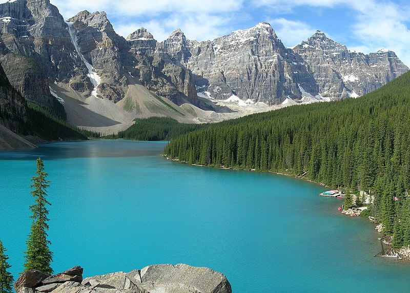
An attraction of the Banff National Park in the canadian province Alberta: the turquoise Moraine Lake seen from a viewpoint at its north bank.
The blue-green color of the lake is due to glacial rock flour.
Rock flour, or glacial flour, consists of fine-grained, silt-sized particles of rock, generated by mechanical grinding of bedrock by glacial erosion or by artificial grinding to a similar size. Because the material is very small, it becomes suspended in meltwater making the water appear cloudy, which is sometimes known as glacial milk.
When the sediments enter a river, they turn the river's colour grey, light brown, iridescent blue-green, or milky white. If the river flows into a glacial lake, the lake may appear turquoise in colour as a result. When flows of the flour are extensive, a distinct layer of a different colour flows into the lake and begins to dissipate and settle as the flow extends from the increase in water flow from the glacier during snow melts and heavy rain periods.
Formation
Typically, natural rock flour is formed during glacial migration, where the glacier grinds against the sides and bottom of the rock beneath it, but also is produced by freeze-and-thaw action, where the act of water freezing and expanding in cracks helps break up rock formations. Multiple cycles create a greater amount.
Although clay-sized, the flour particles are not clay minerals, but typically ground up quartz and feldspar. Rock flour is carried out from the system via meltwater streams, where the particles travel in suspension. Rock flour particles may travel great distances either suspended in water or carried by the wind, in the latter case, forming deposits called loess.
Banff National Park
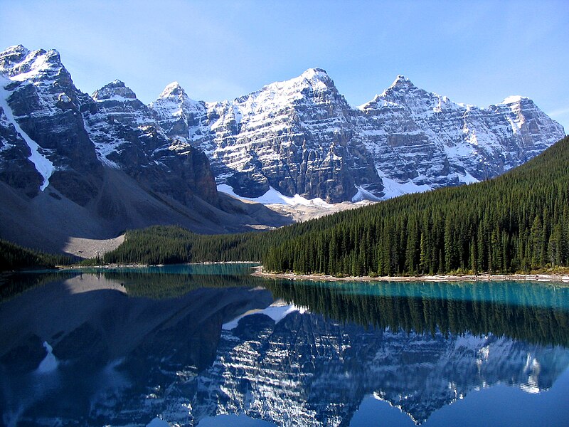
Valley of the Ten Peaks and Moraine Lake, Banff National Park, Canada. Mountains from left to right: Tonsa (3057 m), Mount Perren (3051 m), Mount Allen (3310 m), Mount Tuzo (3246 m), Deltaform Mountain (3424 m), Neptuak Mountain (3233 m).
Banff National Park is Canada's oldest national park, established in 1885 in the Rocky Mountains. The park, located 110–180 km (68–112 mi) west of Calgary in the province of Alberta, encompasses 6,641 km2 (2,564 sq mi) of mountainous terrain, with numerous glaciers and ice fields, dense coniferous forest, and alpine landscapes. The Icefields Parkway extends from Lake Louise, connecting to Jasper National Park in the north. Provincial forests and Yoho National Park are neighbours to the west, while Kootenay National Park is located to the south and Kananaskis Country to the southeast. The main commercial centre of the park is the town of Banff, in the Bow River valley.

Lake Louise - Banff National Park, Alberta, Canada.
Lake Louise is a hamlet in Alberta, Canada within Improvement District No. 9 Banff (Banff National Park).
Valley of the Ten Peaks and Moraine Lake, Banff National Park, Canada. Mountains from left to right: Tonsa (3057 m), Mount Perren (3051 m), Mount Allen (3310 m), Mount Tuzo (3246 m), Deltaform Mountain (3424 m), Neptuak Mountain (3233 m).
Valley of the Ten Peaks is a valley in Banff National Park in Alberta, Canada, which is crowned by ten notable peaks and also includes Moraine Lake. The valley can be reached by following the Moraine Lake road near Lake Louise. The ten peaks were originally named by Samuel Allen, an early explorer of the region, who simply referred to them by using the numerals from one to ten in the Stoney First Nations Language. He may have learnt the terms from his Native American guides, who helped him with the horses. The Nakoda - also known as the Stoney Indians - is a tribe whose culture and dialect are closely related to that of the Assiniboine First Nation, from whom they are believed to have separated in the mid-1700s, and who roamed large parts of the prairies and mountains of western Alberta well into British Columbia. The secluded Valley of the Ten Peaks was part of their original homeland. Gradually, though, all but three of the mountains were renamed in honour of noteworthy individuals, including Allen himself.
(source: wikipedia)
(credit to: wikipedia)